Monday, April 26, 2010

Yellow Creek State Park - 4/10/2010


Yellow Creek State Park was another lake that I'd heard about and wanted to try, but knew nothing about. I was surprised by the size of it. It's a large, open lake with a lot of smaller coves to explore. The weather was sunny and cold, but very windy the day I was there. The wind whipping across the lake created some pretty rough conditions that, at times, tested the limitations of my 10 foot Fusion kayak. I was tossed around like a cork while crossing some of the larger expanses and was really wishing I would have gotten that spray skirt I had my eye on. Most of the time it's nice having such a large cockpit opening, but this wasn't one of them. Yellow Creek is a beautiful place though and I really enjoyed my day paddling there. The coves and creeks were sheltered and calm, and the rough water of the lake made for a great core workout.

Yellow Creek

Little Yellow Creek

* The park is named for Yellow and Little Yellow creeks, which create the lake. The creeks have lots of yellow clay in the banks and bottoms.


My Garmin track log for this trip can be found in the Track Log section.

Saturday, April 3, 2010

High Water And Mud


The past three weekends I've been on four paddling trips on four different bodies of water but they've all had one thing in common, high water and mud. All the waters in our area were affected by the snow melt off and resulting flooding, but the three dam created lakes that I've been on have really taken a hard hit.


Loyalhanna Lake & Infow Creek - 3/27/2010
I went to Loyalhanna last Saturday for a late afternoon paddle.I wanted to see how high the water was and I wanted to work my way upstream on the inflow creek a little farther than Robbin and I had gone in the fall. Someone had written on the Pittsburgh Kayakers website that the water level behind the dam was 32 feet above normal. I thought that it must have been a misprint.


A fellow kayaker, who was loading up when I was putting in, told me to keep track of the channels I was taking because it was easy to get turned around a lose your way with the water up. He also said that it was even higher the previous week. It was so high that the cliffs were under water and you could also look down into the osprey nest.


This is how the cliffs looked last fall.

The same cliffs as they looked on 3/27. They were underwater only a week earlier.


Keeping track of landmarks as I made my way upstream was really good advice. At one point I thought I was in the main creek channel only to come to a dead end. Fortunately I was able to paddle over what is normally dry ground to get back on course. It was a maze and I started looking ahead and behind to make sure I could find my way back. Check out my GPS track log in the Garmin Connect section in the side column. The Google map shows that I spent most of my trip paddling on land.


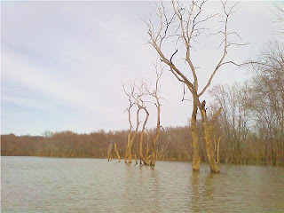
This photo shows that the 32 foot water level was probably pretty accurate. Check out the log tangled in the branches. It's about 20 feet off of the ground.


Mahoning Creek Lake 4/2/2010

This is the mud part of the story. I had never been to Mahoning Creek Lake but I've heard a lot about it. Robbin had to work on Friday, so I decided to go there early and make a day out of paddling new water. I left before 8 am to make the 40 minute drive to the lake. I had a pretty good idea where it was, where I wanted to launch from, and I had a semi-detailed map that I printed off of the Army Corp. of Engineers website (see Maps & Resources section). I made it to my projected starting point without a hitch, only to find it closed due to high water (imagine that). This is when I found out how semi detailed my map was. I started to drive to an alternative launch site and made a wrong turn. The area around Mahoning Creek Lake is very rural and most of the roads, it seemed, were unmarked dirt roads. I followed signs for the lake and ended up at the dam (not where I wanted to be). I back tracked and found the road I had missed (not the maps fault as it turns out. The problem was "trekker error"), but I didn't get on the water until a little past 10 am.


I headed upstream to start my journey. You can tell that this will be a beautiful place later in the spring. The hillsides, under the trees, are blanketed in Mountain Laurel and there are huge rocks every where. I was told by a friend, who lives in the area and canoes there regularly, that you can watch the eagles diving in and taking fish right in front of you. Right now though, it's just a sea of mud, rock, and tangled drift wood along the banks. I'm really looking forward to going back there in a few weeks,though. The leaves will be on the trees, the Mountain Laurel will be in bloom, the eagles will be fishing, and hopefully the mud will be gone.
You can find the track log for this trip in the Garmin Connect section.


Mountain Laurel is growing everywhere.


This guy wasn't too happy with me disturbing his fishing. I followed him up and down the creek for about a mile in each direction.


These riffles were the end of my journey upstream. I paddle about 100 yards through them but "ran out of steam". It was too early to be worn out so I turned around. As fortune would have it, had I put in at the launch I had originally wanted to use, I would have had to paddle through or portage around these riffles (in the mud) to get back to my truck. I guess it worked out for the best :-)


Friday, March 26, 2010

Crooked Creek - 3/21/2010


It was a beautiful day last Sunday (March 21) and I really wanted to go for a longer paddle. I asked Robbin if she had any interest in joining me, and to my surprise, she said yes. I was surprised because only a day earlier she told me that you wouldn't catch her in a kayak until she could go in shorts and a tank top. It did come with the condition that we would turn around when she got tired, though. We decided to go to Crooked Creek because the last time we were there we couldn't figure out what was lake, what was inflow area, and what was creek. There were little branches that split off the lake, and we didn't know if we where actually on Crooked Creek or a branch of the creek. We were going to retrace our previous route with the GPS unit so we could see exactly what was what.


When we started out we could see that the water level was really high in the lake. We had no idea just how high until we got to the spot where the creek feeds into the lake. The area was hardly recognizable as the place we had been to so many times last fall. Where there was land that separated the channels from the lake, and each other, there was now water. It looked like the Bayou.


The mouth of Crooked Creek where it feeds into the lake in September of '09.

The same spot on March 21. You can see from the mud lines in the trees that the water was once 10 feet higher than it is in this photo.


We had a great time paddling through the trees as we made our way up the creek. We were trying to recognize anything to get our bearings, but the only things that were familiar were the bends in the creek. We paddled slightly past the bend where we ended our Fall trip and turned around to head back.

When we got home I downloaded the data off my GPS unit to my computer so we could see where we'd been. This GPS stuff is great. I create a track log on the unit when we start out, then save it when we finish. We I get home I connect the unit to my computer via USB cable and a program named Garmin Basecamp pulls the information from the unit and saves it in a file. I upload the file onto a website named Garmin Connect and it plots the track log on to a Google map along with various stats. I can also add as little or as much information as I want about that "activity". Fortunately I can also share this. You can access the information about this trip by clicking on the title of this post or under the Garmin Connect Track Logs heading on the side.


Thursday, March 25, 2010

The 2010 Paddling Season Begins......Finally!


It was a long winter, but the 2010 paddling season has finally begun for the Swanks. My cool/cold water apparel arrived from NRS and I was ready to hit the water. Actually that was my 2nd order from NRS. My first apparel order wasn't really very.....stylish, I guess that's a good way to put it. It was, however, a source of great amusement to my wife and everyone else she sent the pictures to, though. I'll get into this story some other time.


I've been wanting to try out Buffalo Creek in Freeport for a while now, but it's too shallow to paddle very far upstream. I'd been watching the creek for the past couple of weeks, since the melt off brought the water levels up, and decided I give it a shot last Saturday (March 20). The current had slowed and I wasn't looking for an all day trip, just something to get my rhythm back and try out my new GPS unit.


There are a few interesting things to look at on Buffalo Creek, some old bridges and rocks, but even with the water as high as it was, it narrowed and got shallow in less than a mile. I doubt that most of what I saw upstream would be accessible later in the spring when the creek level falls.


There were two sections of riffles that were a pretty good work out. I paddled through the first set a couple of times. The second set was the end of my journey upstream. The creek split around a small island. The current was too swift and shallow to get enough paddle in the water to power through. I could see that the creek got a little deeper beyond that point, but there was no way to portage around that section. The creek bank was too soft and I didn't want to walk in the creek and risk falling and maybe having to chase my kayak down stream. I tried to get around it by landing on the island and putting my kayak back in on the other end, but this ended with me almost going for a swim. I put one foot in my kayak and pushed of with the other. Before I could sit down, the current caught the kayak and spun it sideways and almost threw me in the water. By the time I recovered I was already through the riffle and back to point A. That wasn't one of my brightest moves.


I decided to head back at that point, I had accomplished what I set out to do. 1.) I got some time on the water at a place I had never been 2.) I got my paddling rhythm back 3.) I learned how to work my GPS 4.) I got the feel for my new paddling clothes, and most importantly 5.) I didn't get wet!


Sunday, February 7, 2010

Maybe I Didn't Give Oldman Winter A Fair Shake


I was pretty hard on "Old Man Winter" in my last post. I'll chalk it up to the "winter blahs". I'm not equipped for cold weather paddling anyway. We had a snowstorm roll in Friday night (Feb. 6) that dumped about 21" of snow in our area. When we woke up Saturday morning, I was reminded just how beautiful winter can be. Our little Victorian "Town Of Winding Streets" was transformed into a vision that belonged in a Norman Rockwell painting. Although it's a lot of work digging out from under that much snow, we enjoyed how life's pace seemed to slow down for a while. There were no cars driving up and down the street and no noise. That must have been what it was like when Vandergrift was a new town in the 1890's.