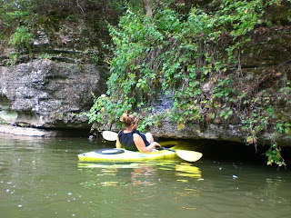
Lake Arthur at Moraine State Park was another body of water that I had on my "Must Paddle" list. I'd read about an area in the north-west corner of the lake called Hidden River Canoe Trail that was supposed to be a great, short trip. Robbin and I loaded up the kayaks on Labor Day an headed north for the 1 hour trip to Moraine.
Hidden River Canoe Trail is located near McDaniel's Boat Launch at Moraine's North Shore. In addition to a regular concrete launch ramp, they have a floating launch ramp that is for canoe and kayak use only. You place your kayak in the recessed area, grab your paddle, give yourself a little push, and you slide right into the water. I wish more places had this set-up.
A brochure is available at the store/boat tour office at McDaniel's Launch. It describes Hidden River Canoe Trail is way: "Hidden River Canoe Trail was established during the Spring of 2000 by members of the Western PA Paddlesport Association in cooperation with Moraine State Park volunteers. The result is a system that winds through scenic coves, wetlands, and a spectacular stream hidden from view."

There are numbered post along the trail. The numbers correspond with those on a map and Points of Interest descriptions that are part of the brochure. I'm going use the quotes from this brochure as the captions to my photos.
Points Of Interest:

1. Hidden among the bays of Moraine exist complex wetland communities. Frogs, turtles, and other amphibians make their homes here. Strange and unusual plants, adapted to thrive in waterlogged conditions, are abundant.

Look for Skunk Cabbage, Cinnamon Fern, Cattails, and Spadderdock water lilies along the shoreline. Wetland plants such as these help to filter and clean the water.

2. Lake Arthur and it's associated wetlands are attractive to many species of waterfowl. Some, such as kingfishers, and both blue and green herons, and some species of ducks, make their homes here year 'round.

Aquatic environments also provide homes for a species of special concern. The boxes located in the bays on both sides of this marker are home to a duck so beautifully colored that it's Latin name, loosely translated, means "Waterfowl in a Wedding Dress". The Wood duck, a cavity nesting species, was saved from near extinction by the placement of boxes such as this.

3. Just against the shore to the right of this marker is evidence of a beaver family's home, only recently abandoned. This family elected not to build a traditional "lodge" for their dwelling, but have instead burrowed into the bank to set up housekeeping. The front door, however, is under the waterline, and is covered with a tangle of sticks and branches to discourage predators.

4. Head for that small, dark cove at the "top" of the lake. This deceptive little bay is the entrance to Hidden River, and while it's small, there is no other place quite like it in the park.

A glimpse into the past is visible from this point in your journey. Look closely at the cliffs on either side of the narrow passage as you paddle in. These Vanport limestone outcrops were originally laid down as sand on the shores of an ancient sea.

How low can you go? (This wasn't in the brochure.)

These limestone outcroppings support unique and fragile plant communities found in few other places at Moraine.

Dead end. (This wasn't in the brochure either.)
*Factoid*
Lake Arthur is a recreation of a lake that was formed here during the last great Ice Age. It was formed when a glacier blocked the flow of Muddy Creek. As the glacier began to melt and recede, it left behind the rocks, gravel, and sand that it had pushed before it on it's advance. This material is called "glacial moraine".

Paddle a little further, and around the bend you will encounter a footbridge which carries the North Country National Scenic Trail over Hidden River.

If the water is up, it is possible to paddle a little way further, passing under the bridge. As you enter the shallows, try to follow the submerged channel of the small creek that once flowed freely here before the lake was created.

5. On the southern point of this cove is an active Osprey nesting platform. To locate the platform, look up above the treeline, very close to the telephone pole, and directly across the lake from McDaniel's Launch.

As you paddle back to the launch area, take some time to ponder the richness and diversity of life around the shores of Lake Arthur. Though this tour is at an end, there are many other coves, bays, and inlets in the Park that await exploration, and each season brings it's own particular changes to the life around the lake.

Hidden River Canoe Trail is just a tiny part of what is a very large lake. I'm really looking forward to going back there soon. I definitely want to go back to Hidden River after the leaves change. It will be breathtaking. I have an "ace in the hole" to get Robbin to go with me too. With all our travels, we've become sort of soft serve ice cream "connoisseurs". Because of bridge construction, you have to detour past a Dairy Queen that Robbin rates as one of the 5 best for creaminess.
"Come on honey, let's go for an ice cream cone....I'll throw the kayaks in the back." :-)


