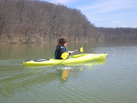

It was a beautiful day last Sunday (March 21) and I really wanted to go for a longer paddle. I asked Robbin if she had any interest in joining me, and to my surprise, she said yes. I was surprised because only a day earlier she told me that you wouldn't catch her in a kayak until she could go in shorts and a tank top. It did come with the condition that we would turn around when she got tired, though. We decided to go to Crooked Creek because the last time we were there we couldn't figure out what was lake, what was inflow area, and what was creek. There were little branches that split off the lake, and we didn't know if we where actually on Crooked Creek or a branch of the creek. We were going to retrace our previous route with the GPS unit so we could see exactly what was what.

When we started out we could see that the water level was really high in the lake. We had no idea just how high until we got to the spot where the creek feeds into the lake. The area was hardly recognizable as the place we had been to so many times last fall. Where there was land that separated the channels from the lake, and each other, there was now water. It looked like the Bayou.

The mouth of Crooked Creek where it feeds into the lake in September of '09.

The same spot on March 21. You can see from the mud lines in the trees that the water was once 10 feet higher than it is in this photo.

We had a great time paddling through the trees as we made our way up the creek. We were trying to recognize anything to get our bearings, but the only things that were familiar were the bends in the creek. We paddled slightly past the bend where we ended our Fall trip and turned around to head back.
When we got home I downloaded the data off my GPS unit to my computer so we could see where we'd been. This GPS stuff is great. I create a track log on the unit when we start out, then save it when we finish. We I get home I connect the unit to my computer via USB cable and a program named Garmin Basecamp pulls the information from the unit and saves it in a file. I upload the file onto a website named Garmin Connect and it plots the track log on to a Google map along with various stats. I can also add as little or as much information as I want about that "activity". Fortunately I can also share this. You can access the information about this trip by clicking on the title of this post or under the Garmin Connect Track Logs heading on the side.


No comments:
Post a Comment